Llyn Arenig Fawr
OS Grid Ref:- SH8438
Llyn Arenig Fawr is a secluded mountain reservoir flanked by steep cliffs and surrounded with heather. Located near to Llyn Celyn, it provides the nearby town of Bala and several villages in the area with water. Llyn Arenig Fawr is situated on the eastern side off Arenig Fawr, close to the summit.
Arenig Fawr rises to 654 metres (2,802 feet) At the summit of the mountain stands a trig point and a memorial to the American air crew of Flying Fortress bomber which in 1943 crashed on Arenig Fawr, the crew of eight all lost their lives.
The Arenigs consist of three main summits Arenig Fawr, Arenig Fach (689 metres) and Moel Lyfnant (751 metres). The views from the summit of Arenig Fawr are spectacular and include most mountain summits in Snowdonia.
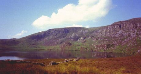
Llyn Arenig Fawr is best approached from the B road to the south of Llyn Celyn or from the mountain road that links Llanuwchllyn to Trawsfynydd.
Image copyright Richard Webb
A walk to Llyn Arenig Fawr
*Commencing from the b road south of Llyn Celyn, from the cattlegrid at grid ref SH857392, follow the southerly track for around 1.5 km then head west over the stream toward the east ridge of Arenig Fawr. Follow a further stream to arrive at the dam at Llyn Arenig Fawr.
*Continue to the southern point of the reservoir to ascend to the summit of Arenig Fawr via the east ridge.
Stay safe, by following a few simple rules when walking in the mountains:-
Obtain a reliable local weather forecast before you set off and plan a route suitable for forecast conditions.
Check your equipment before leaving, take waterproofs, spare warm clothing, hat and gloves. food and drink, a map, a compass and a survival bag.
Learn basic mountain skills, particularly navigation.
If weather conditions turn bad, turn back.
Don't rely on mobile phones.