Cadair Idris
OS grid ref:- SH 711130
Cadair Idris, or to use its anglicised title of Cader Idris, derives its name meaning 'Chair of Idris' from the giant warrior poet of Welsh legend.
The mountain looms menacing and primeval over the surrounding landscape. Cadair Idris consists of a massive 11km long ridge and although only the 19th highest mountain in Wales, is the second most popular mountain in the country after Mount Snowdon.
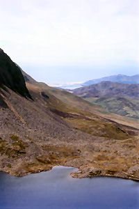
The summit, Penygadair (Top of the Chair) at 2,927 feet (892m), offers a superb panorama of mountain scenery. The mountain is notorious for its low cloud but on a clear day it is possible to see the mountains of the Snowdon massif and the Rhinog mountain range as well as the Lleyn Peninsula and the hills of Shropshire, the Long Mynd, the Wrekin and occasionally Ireland.
To the north of the summit lies the very steep and craggy north face, where the cliffs drop around 200 metres. The other peaks of the ridge are Mynyyd Moel (855m), Pen-y-Gader (893m) and Mynydd Pencoed (798m).
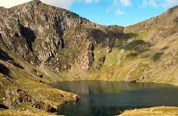
The mountain consists of a long ridge, its northern face is craggy and precipitous, in contrast to the south face which slopes more gently into the broad expanse of the Dyfi estuary. There are a number of paths which lead to the summit, the Fox's Path leads directly up the mountains north face.
North of Cadair Idris lies the town of Dolgellau, a convenient base, which offers a wide range of accomodation, cafes, restaurants and shops.
Paths to the Summit
Minffordd
length - 10km (6 miles)
ascent - 874m (2,885 ft)
duration - 4 - 6hours
steepest, most dramatic approach, well marked path, superb panorama of mountain scenery.
From the car park behind the Minfford Hotel (OS grid ref. SH732115) follow a track leading north. After the visitor centre follow the path uphill through the woods. When reaching a level area turn west following the path to the summit of Craig Cwm Armach. From the summit, cross a stile and head downhill. Follow the edge around top of Cwm Cai, rising up to Pen-y-Gadair.
Pony Path
length - 14.6km (9 miles)
ascent 888m (2,820ft)
care must be exercised where path approaches cliffs.
Starting from the car park at Ty-nant (OS grid ref. SH697152) turn right and follow the lane. Before a telephone box on the left take the track that leads onto the pony path. Emerging into a wide col the route from the summit heads east. Take care when the path nears the top of the cliffs. turn right along the edge of the precipice. A scramble leads to the summit trig point.
Stay safe by following a few simple rules
Obtain a reliable local weather forecast before setting off and plan a route suitable to those conditions.
Check your equipment before leaving, take waterproofs, warm spare clothing, hat and gloves, food, drink, a map, a compass and survival bag.
Learn basic mountaineering skills particularly navigation.
If weather conditions turn bad, turn back.
Don't rely on mobile phones.